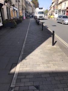
Riding from Combe Down to Widcombe on Ralph Allen Drive is a lottery of uneven road and potholes. The whole of RAD needs resurfacing. The Drive is positively dangerous for people on bikes and not good for motor vehicles either. It must be getting on for 20 years since it was last resurfaced.
Contra flow in Widcombe
The first provision for bike riders is at the bottom of Prior Park Road where riders can turn left into a “contra flow”, ride on a segregated route against the normal traffic flow, then ride to the crossing on Rossiter Road.
Once across, a right turn takes you on to the towpath and into the city centre at Pulteney Bridge. Left and the rider is asked to dismount over the half penny bridge, as walkers and riders are thrown together into a very small space. It would be better if there were no barriers here to provide more space for people crossing the river, with perhaps a “Share with Care” notice in place.
If the rider wishes to go towards Churchill Bridge the pavement is very little used and is in any case wide enough for careful riders and walkers. Access across the river is over the wide footbridge next to the bus station. From here it is but a short distance to the new shared path leading to the new bridge at Newark Works or on to the river tow path. The new bridge is wide, so plenty of room for walkers and riders.
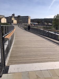
New bridge to Newark Works
The bridge crosses the river and takes you to Mokoko bakery and cafe, which has plenty of cycle stands along the whole of the building and outside eating, which gets the full sun in the morning.
The anticipation must be that this area will become over time a much used area with more businesses and most employees coming to work by walking and cycling.
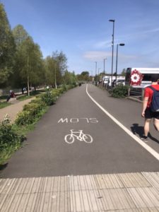
The approach to Newark Bridge
The approach to Newark Bridge is by a newly constructed shared path, about the same width as Newark Bridge giving plenty of room. It is a shame that if people are not going over the Bridge they have to just join the road and take their chances with traffic.
Despite all of the improvements in infrastructure for cycling, many of the new facilities do not link together. This really is a shame that more thought is not given to joining up some of the recent developments in infrastructure. Despite the Climate threat to the planet many people disregard the threat as soon as actions limit their own ability to use their own personal transport.
The next section and photos illustrate the excellent segregated cycle lanes on the Upper Bristol Road. These are a first for Bath. The photos also show how the bus stops integrate very well into the cycle lanes.
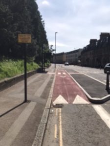
Bus stop on inbound cycleway
The photo on the right shows how bus stops, can be very clearly fitted into the cycle lanes and notices explain to bus passengers that they have priority over people on bikes in these positions.
These cycle lanes are classed as “Quickways” in Oxford and are under consultation at present. The principle here is that for riding bikes to become a part of normal commuting segregated cycle routes need to be on main roads used by all vehicles for commuting. Usually the quickest, most direct route.
In an earlier post On this blog I describe a survey that I did in Oxford on the Iffley Road to show how a “Quickway” would work. Councils often find the most difficult part in these cycle routes is providing safe bus stops. B&NES have shown that it has officers with the ability to solve this most often presented problem. However both the inward and outward cycle lanes on the Upper Bristol Road eventually drop people on bikes into the normal vehicular traffic flow.
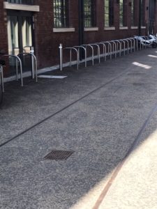
New cycle stands at Newark Works – great provision for the future
There is a need to look carefully at how these segregated cycle lanes go as far as possible into Queen Square, at the city end and link to the off-road CycleBath at the Globe straight. From the end of the Globe Straight a segregated cycle route to Saltford to link with the off road route into Keynsham Would be a really good route linking Bath with Saltford and Keynsham.
Certainly the Lower Bristol Road should also be looked at for a segregated cycle lane such as the one on the Upper Bristol Road. There is certainly potential for a route here on the main road.
My criticism of these cycle routes, despite enthusiasm for what has been achieved, is that when they are conceived the maximum extension should be planned at the outset. Routes should be planned to be complete, linking destinations, not just finishing and disgorging bike riders into vehicular traffic.
A start on looking at complete routes for bikes along main roads – London Road, Upper and Lower Bristol Roads, the A4 to Saltford and Keynsham and completing the partially done route on Wellsway – would be a good way to begin a comprehensive cycle network for Bath and surrounds. I also wonder when the long expected “Scholars Way” will ever be completed? There would be real challenges to B&NES officers to use the expertise shown on the Upper Bristol Road and to apply it to other main roads. However, the real solution to providing cycle routes in the Authority remains with the Liberal Democrat Administration and the Greens.
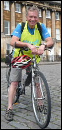 Hello, I'm Roger Symonds and I have created this blog to highlight local and wider cycling issues. Given the incredible interest and increase in cycling we must not miss this opportunity to provide the the infrastructure that gets even more people out on bikes in a safer environment.